III. B. 4. The “Temenos + Delta + Xanthi & Drama Plains” Alternative (DOALL) . 7
Geointelligence is a technical and economic science related to Economic Intelligence. It must be apprehended under the American meaning of ‘Intelligence’, i.e. referring to all methods allowing the gathering, protection and assimilation of economical and strategical information, in order to ensure the competitiveness of firms, the development of the economy and the empowerment of a nation. Thus, geointelligence will focus on information about every geo-oriented aspect of a problematic, from geography to geology (geophysics, geohydrology), to geopolitics and environment.
A dam project is a project that utterly fits within the expertise of geointelligence, since the construction of a dam needs exhaustive information about geology, as well as geopolitical, hydrogeological and economic information in order to assess the profitability and the environmental safety of the dam before its construction, and to plan the management of the dam after its construction.
The project of the construction of the Temenos dam lends itself to a geointelligence study more specifically, because it involves a Greek river that takes its source in Bulgaria. Water ressources management in such transboundary conditions affects different parties as the Public Power Corporation (DEH in Greece), the Greek and Bulgarian governments, the European Union, or the investors. Necessarily each actor has different development plans for his entity, and will therefore strive to collect exclusive information in order to influence the final decision at his own advantage.
In our study, the focus is set on the different kinds of information that we can gather and the way we can use them. In fact, geological and geographical information was used to design a numerical model of the region. Figures from economic and climate predictions were used to establish the profitability of different versions of the Temenos Project. Finally, qualitative information on policies and the goals of some of the parties were introduced to assess how each criterion can be accounted for in the project.
The final goal of this study is to counsel one of the actors involved in the project, to give him a general opinion on the possible alternatives and to establish which one of these project alternatives is the best one according to his priorities. Our group had to advise the government of Bulgaria, in preparation of future meetings with the others parties.
The Mesta/Nestos are two different names referring to the same river, which springs out in Bulgaria, crosses the boundary between Bulgaria and Greece 126 km after the spring and finally pours into the North Aegean Sea after a 130 km course in Greece. The Bulgarian watershed is named Mesta, the Greek one Nestos (ref. Figure II.1). The larger affluent of the main river is called the Dospat and flows mostly in Bulgaria: the confluence happens shortly after the border.
During its entire course in South-Western Bulgaria and Northern Greece, the morphology of the catchment is mainly mountainous, except for the final Delta plain. The climate of this region is Mediterranean, with influences of Continental climate in the North of the Mesta river basin.
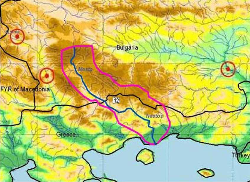
Figure II.1: Location of the Mesta/Nestos River
Two dams, Thisavros and Platanovrisi, already exist on the Nestos to produce hydro electrical power. A last reservoir, Toxotes, is built on the river for the purpose of irrigating the fields in the Delta.
Drinking water in the area is extracted exclusively from underground catchments.
Irrigation water in a Mediterranean climate is an important part of the water resources used in the area, as the quantity and quality of crops, with warm weather, are only limited by water. The largest agricultural plains around the Nestos are the plains of Xanthi and Drama and the delta (ref. Figure II.2). The farmers, until now, have obtained the irrigation water mainly from wells.
No fee is asked for this water nowadays, however the Water Framework Directive, established by the E.U. in 2000, asks that any use of water should have its price (scheduled for 2010). This will have consequences in the way farmers will get their water supplies.
Another problem is caused by the geology of the area. The presence of karstic formations - where groundwater is not kept in an aquifer but can flow freely in underground cavity systems - renders more difficult the understanding of the water cycle and therefore of the available ressources for there is no actual valid model for simulating those geological characteristics. For now, no one can predict how long that flow can last.
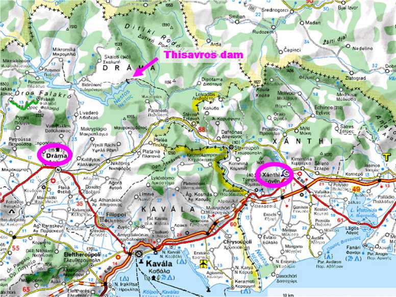
Figure II.2: Map of the Nestos area (source: viamichelin.com)
In connection to the water resources of the Nestos, it is also important to indicate the presence of a riparian ecosystem along the river, and the existence of coastal wetlands (such as lagoons) well-known as a bird-nesting site. Without enough water those ecosystems may be damaged.
On the Bulgarian part of the Mesta/Nestos watershed, there is no large hydropower complex on the Mesta river arm; however, an important complex is built on the Dospat.
The presence of the Rila and Pirin mountains in the Northern part of the river basin is important due to the amount of water entering in the hydrological cycle from snow melt. This source of high-quality freshwater is a crucial component to supply Sofia in drinkable water.
Also, more recently, ski-resorts and other mountain tourism activities have been developed near the towns of Razlog and Bansko.
The land use in the Mesta watershed corresponds with traditional agriculture and forests. In the future, the economic activities are predicted to be more related to tourism and less centered around traditional agriculture.
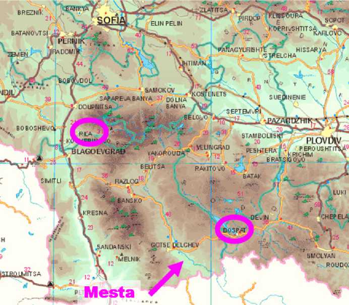
Figure II.3: Map of the Mesta area (source: get.info.bg/visit/)
II. C. POLITICAL FACTORS
Because of this transboundary conditions, the river has brought about conflicts between the two countries. Nonetheless, on October 19th, 1996, Greece and Bulgaria came to a bilateral agreement stipulating that Greece could use 28% of the mean annual run-off of the Mesta River... with no mention of the flow coming through the Dospat.
Also, the treaty did not specify the seasonal variation. This limitation on the Nestos river could have direct consequences on the environment of this region in the coming years: since the most recent models forecast that the climate could get warmer and dryer in Mediterranean regions, summers can become problematic, being a period of peak demand for water and electrical power supply.
The influence of the E.U. should also be considered, since Greece and Bulgaria will soon be both members of the E.U.: Europe is a source of financing but also of laws.
The purpose of the project is to develop the irrigation system in the surrounding area of the Nestos River and the production of electricity by the construction of a dam. Following the name of the future dam, the project will be called the “Temenos Project”.
The relevance of the Temenos Project has been established since the construction of the two existing dams in the 90s. But because of the lack of money to finance the whole project, the Temenos dam was set apart at the time. Nowadays with the potential contribution of private investment, the project is back on its tracks.
III. B. SUGGESTED ALTERNATIVES
Several options are to be evaluated. Since the probable evolution of several crucial parameters of the project and the appeal caused by limited risks to finance entities, it is necessary to establish the lasting quality of the chosen solution.
The NODO alternative is the reference option. In this case, the dam is not built: the Nestos dams’ complex remains as it is at present with Thisavros and Platanovrisi producing electricity and regulating the water used for the irrigation of the Delta.
This means that no money has to be invested directly for the construction of the dam. However the impacts of this option, in a general perspective, cannot be set aside: farmers will have to find other sources of water, and the electricity production will have to find other ways to fulfil the peaks of power demand.
The second alternative consists in the construction of a third dam, the Temenos dam, on the Nestos River, downstream from Platanovrisi, ensuring the irrigation of the Nestos delta’s fields (ref. Figure III.1, in part III.B.4).
The dam is designed to provide 20 MW of electricity and will also be used in “piggyback” with Platanovrisi allowing water to be pumped upstream in the low hours of electrical demand. This second feature imposes a fixed height of water in the lake dam to allow the pumps to be underwater.
The TEDLX alternative is an increment of the previous alternative in which the dam is planned to also provide water for the irrigation of the neighboring Xanthi plain.
The water for the irrigation purpose is planned to be withdrawn from the river flow downstream from Temenos at the already existing Toxotes reservoir (ref. Figure III.1, in part III.B.4).
It is important to underline that not all the existing flow of the river can be diverted for agricultural purposes: the wild part of the delta cannot be preserved without a minimum amount of water.
This last option is to develop the dam, the downstream irrigation of the Nestos delta and the Xanthi plain and a derivation of water from the Platanovrisi dam in direction of the plain of Drama (ref. Figure III.1).
For a better prediction of the dams’ system, it is necessary to estimate the quantity of water that each irrigation set (delta and plains) represents and to bring this data into line with the flow that can be taken away from the river.
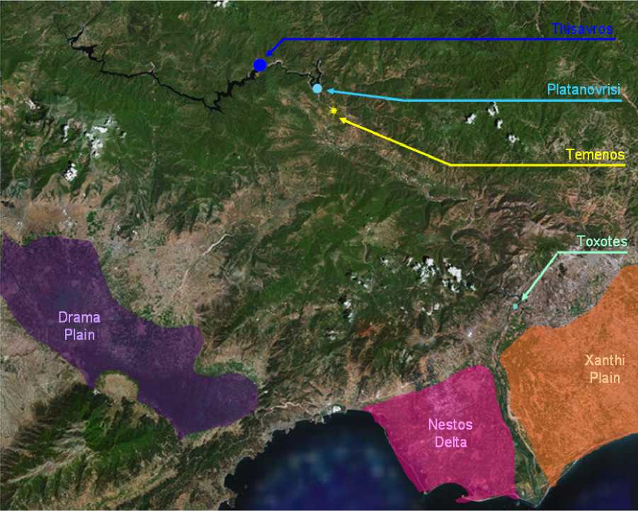
Figure III.1: The different elements constitutive of the alternatives (based on Google Maps 2006)
The key to the success of the project is the ability to give an accurate estimation of the water resources available during the life time of the dam in comparison with the market demands for water and electricity. Obviously as the realization of the dam might take more than ten years and as a dam is designed to last fifty years or more, the evaluation task of all the involved parameters is not trivial.
Therefore the goal of the feasibility study is to establish predictions according to future scenarios. Fortunately, it is possible to find various studies on future predictions regarding several relevant topics and also models established and validated by scientists able to simulate the results of given scenarios.
Other aspects like the technical design of the dam and the irrigation system or the impacts on the environment and their remediation should also be considered in more details in a further analysis. But as the major meaning of this report is to guide the choice of an out coming solution, these aspects can be set apart for now.
As a working hypothesis, it will be assumed that:
■ there is no technical difficulty associated with the realization of the project considering its dimensions,
■ the greater the impacts on the environment will be, the more elements have to be built; but as it has been mentioned before, it is necessary to consider in counterpart the impact of an irrigation system based on karstic water.
IV. A. DATA ASSESSMENT
In order to run the ResSim model that is used to simulate future operational situations of the dam (ref. IV.B), data is needed for the input variables and the model parameters. This data can be classified into different categories:
■ hydrological data: all data needed to appreciate the flow of the river,
■ climatic data: coupled with the hydrological data in a rain-runoff model (inside ResSim),
■ market data: all information regarding the consumption of electricity and the water demand for the irrigation,
■ constraints data: all the values that are fixed by external means or that are intrinsically tied to the system.
The most important fact to remember is that all this data comes at a given time and space scale. And those scales do not have to be the same for all the data. One of the principal concerns of the simulation is to estimate how to be able to change from one scale to the other without losing too much accuracy. It is obviously simple to go from smaller scales to bigger ones by using average calculation; however the contrary process, called downscaling, can appear harder.
❖ River basin mesh:
The determination of the river mesh and of the boundaries of the watersheds is the first and primordial step of hydrological simulation. Those data are calculated using
DEM (Digital Elevation Models): the slope between adjoining cells gives the probable direction of the water flow –downhill–. For example, NASA provides a 90 m resolution grid covering the world for free (i.e. a value each 90 x 90 m²).
❖ Land Cover related data:
Land Cover/Land Use data can be an interesting set of data in order to establish how the surface will react with water flow: the kind of features presents in the area (urban/non urban, forest/fields, etc.) has a significant influence on the infiltration and potential evapotranspiration (PET).
For European countries, the European Environment Agency (EEA) has developed a common classification – the Corine Land Cover (CLC) – updated in 2000 with satellite imagery. The grid is made of 25 hectares cells and the information is defined in 44 classes. Figure IV.1 shows an illustration of the information provided by CLC for the Temenos project area.
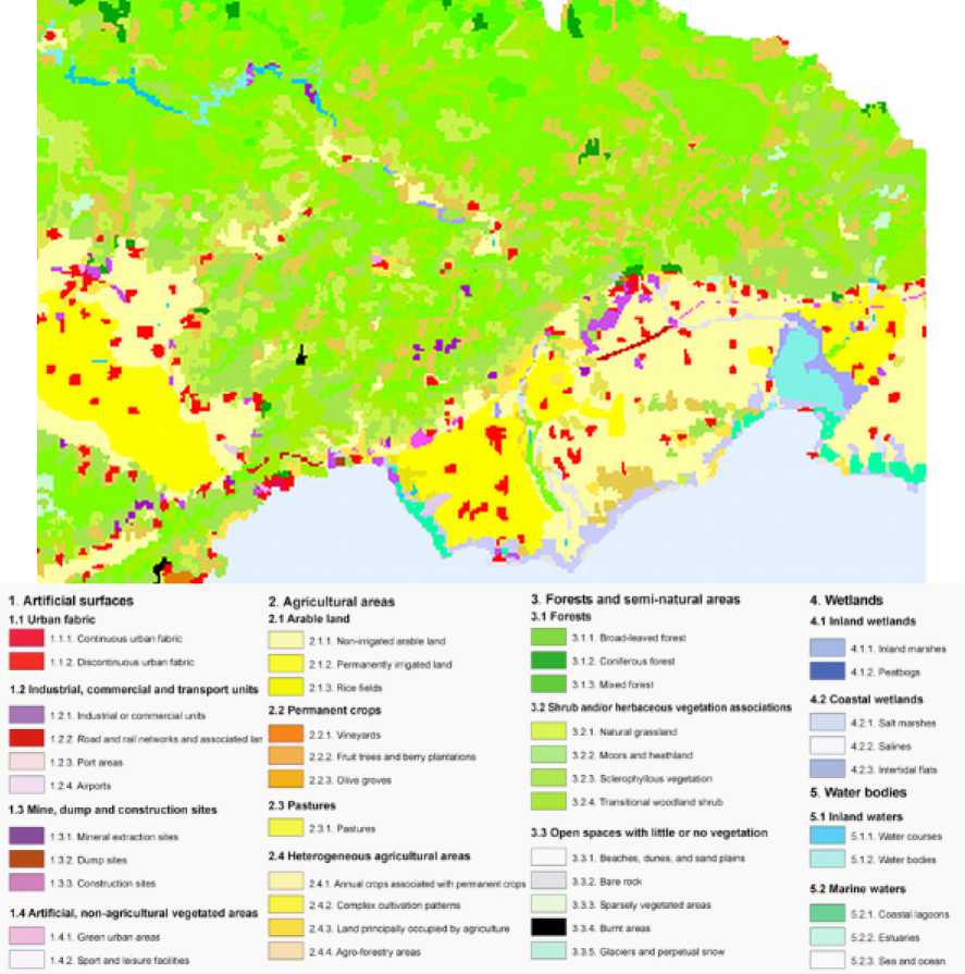
Figure IV.1: CLC in the Nestos river neighbouring
(source: European Topic Centre on Terrestrial Environment)
❖ Geological data:
Geological data is an important compound for the evaluation of the infiltration rate in the hydrological cycle. It also has to be considered while designing the dam itself. Several sources are available.
❖ Underground water.
For a complete vision of the water cycle, the underground waters should be taken into account (on their own and in their exchange with the surface runoff).
However, as no aquifer system has yet been modelled for the Mesta-Nestos region and as the presence of karstic formations associated to subterranean rivers hardens the system, the underground component will be disregarded. Only the surface flow will be considered and the exchanges with the underground flow will be taken as two parameters: an infiltration rate and a compound of the final runoff.
Climatic data is fundamental for the simulation of the hydrological cycle. The calibration and validation of the majority of existing flow models need sets of precipitations and runoff time series. The more accurate the information, the less uncertainty exists in the simulation; the longer the time series, the more representative is the simulation: so climatic data is of the utmost importance among the inputs of the model.
In the case of a dam project, the great problem is to estimate the water resources that would be present during the operational lifespan, which represents predictions from ten to sixty years.
❖ Past time series:
These series are the ones used in the calibration and validation phases. The following series are needed:
■ precipitations: meteorological stations provide records of precipitations. Those data can be extrapolated to an entire region.
■ PET: the potential evapotranspiration can be estimated according to a formula putting in relation parameters such as temperature, albedo, wind, land cover, etc. In the case of the Nestos area, only data for the region of Drama have been found. Those values would be assumed to be true for the area of study.
■ river runoff: stations along the river provide records of the flow.
The past climate series hereinafter correspond to a period between 1970 and 1996 (ref. Figure IV.2).
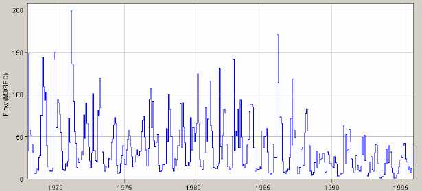
Figure IV.2: Monthly flow observed at Temenos (HEC-DSSVue display)
❖ Future scenarios:
Nowadays the climatic change that awaits the planet is not deniable any longer. So it is important for the simulation of the project to be able to reflect this parameter.
Scientists working all around the world, gathered in the Intergovernmental Panel on Climate Change (IPCC) group of the United Nations Environment Programme (UNEP), have developed several future scenarios of the evolution of climate at a planetary scale due to humans activities. Those simulations are established upon given evolution of CO2 (ref. Figure IV.3), NO2, CH4 or SO2 emissions. Several members of IPCC give access to their simulation results.
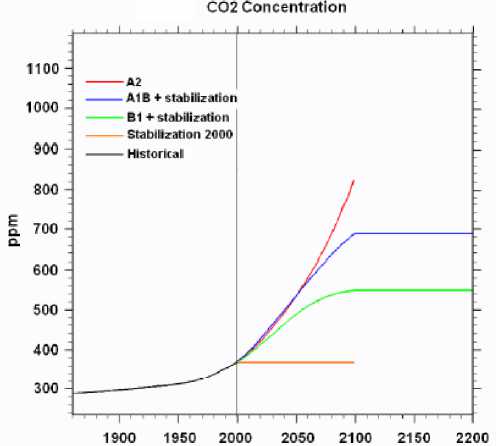
Figure IV.3: Climate Change Scenarios according to CO2 emissions
(source: Presentation of P. Braconnot, CEA)
In the modeling hereinafter (ref. IV.B), and because the object of the report is a first overview of the project, two possible “extreme” scenarios are kept in the simulations:
■ the reproduction of the actual climate, using the past time series: this would be a best case scenario;
■ the climate change scenario A2, using the results of the Hamburg World Data Center for Climate (CERA): this case being on the worse side of the climate evolution range. The results are given under the form of average precipitations on 200 km² grid cells. In the project simulation, the yearly values will be used and the hypothesis that there is a linear relation between rain and flow at monthly time scale will be taken in order to reconstruct the flow.
The starting point of the simulation is 2016, the time when supposedly the dam will be operational. The ending point is 2066.
Market data must provide the information about the consumptions of the project products, i.e. of electrical production but mostly, in this simulation phase of the feasibility of the project, of the water needed to irrigate the retained areas of the chosen project alternative.
The needs for irrigation are evaluated by a mean value putting in relation the present crops (weighted by relative surface occupied) and the consumption of water by season of each variety.
It can be interesting to research the wells present on the river basin and the amount of water that they withdraw from groundwater, to improve the production-function of the hydrological model.
This point gathers all the data needed in the simulation that in one way or another constraints the reaction of the system.
❖ System Dimensions:
The geometry of the dam is one significant input of the model: the operational levels (set by the position of the ducts going to the turbines), the maximum height of the water in the dam, the optimal level allowing “piggy-back” actions, etc.
❖ Flow constraint:
Previous studies made for the two existing dams have established that the survival of wild life and the preservation, against erosion, of the delta wetlands (beaches, lagoons, etc.) can be prevented by a minimum amount of flow fixed at 6 m3/s. The dams’ complex must try to guarantee this minimum flow at any rate.
IV. B. METHODS
The simulations run in order to evaluate the behavior of the dams’ system involve several models, if the transformation of the initials data is taken into account. But the primordial model that must be part of the study is a model able to establish the functioning of the dams: the ResSim model and software has been chosen in this analysis.
HEC-ResSim, for Hydrologic Engineer Center – Reservoir Simulation, is a piece of software developed by the US Army Corps of Engineers (US ACE) in order to model reservoirs under operational constraints. This application can be downloaded for free although US ACE does not provide technical assistance to non-member of US ACE aside from the technical documentation.
ResSim’s structure hinges on 3 principal modules:
■ the watershed setup module which gathers the information layers regarding the watershed definition,
■ the reservoir network module which defines the physical and operational parameters of the reservoir network as well as the different alternatives to simulate,
■ the simulation module which allows the management of the simulation data from time window to computational parameters.
It is necessary to proceed according to the following outlines.
❖ Data gathering:
All the information needed for the modelling must be collected. It is important to have at this point an idea of the precision or of the estimations quality related to all the data: the accuracy of the modelling will rely on this.
❖ Watershed setup and Network definition (ResSim):
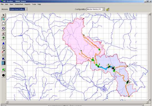
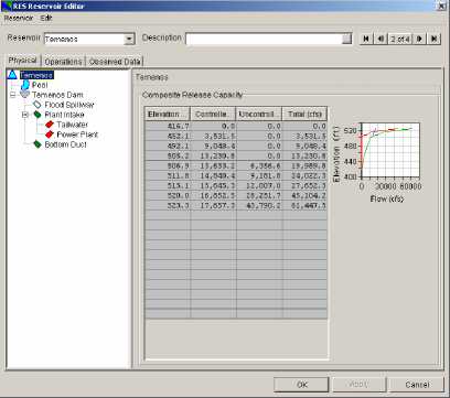
Once the data are available, it is necessary to introduce the information in the application. More details about how to realize this phase can be found in the ResSim User Manual provided by US ACE. Figure IV.4 shows what the modules look like for the Temenos Project.
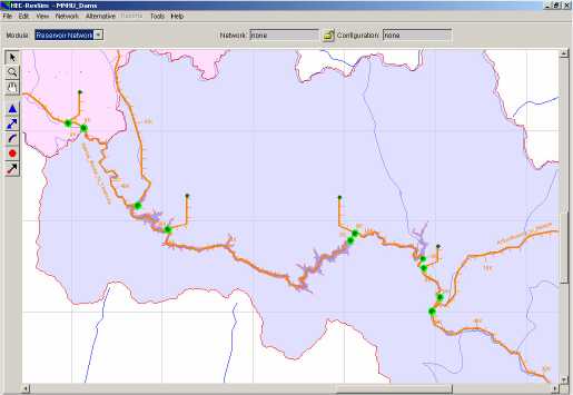
Figure IV.4: Watershed Setup and Network Forms (ResSim display)
❖ Simulations running (ResSim):
During this stage, the different alternatives must be computed. The alternative tree represented in Figure IV.5 shows the classification of the simulations that have to be run to evaluate the feasibility study.
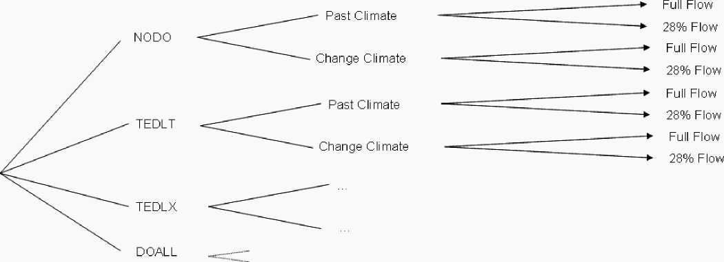
Figure IV.5: Simulations’ tree
Within each simulation the following constraints rule the system –in decreasing importance order–:
■ a flow of 6 m3/s must reach the natural delta (whenever it is possible),
■ the amounts of water requested by the irrigation systems must be provided,
■ the Temenos lake level must be at 150 m because of the pumps sending back water to Platanovrisi.
If any of these conditions cannot be complied, the society responsible of the dam complex will have to pay a financial compensation: this consideration has its importance in the project’s economical feasibility.
Figure IV.6 shows how some of the simulation module features.
Reservoir Editor ^
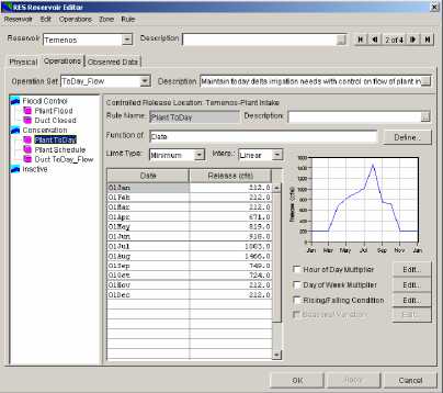
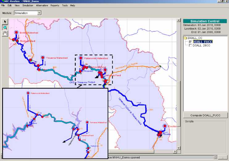
Figure IV.6: Simulation Features (ResSim display)
❖ Results analysis:
ResSim allows the visualization of several charts resulting from the simulations. The general trends revealed are discussed in part IV. C.
In fact the results of the simulation are reported into files. It is then possible to design an extraction procedure in order to transfer all needed information to, for example, an Excel sheet: that is the underlying link between the simulations in this part and the economical feasibility (ref. part V).
IV. C. RESULTS OF THE SIMULATION
The objective of this part is to enlighten the general trends that appear in the simulations.
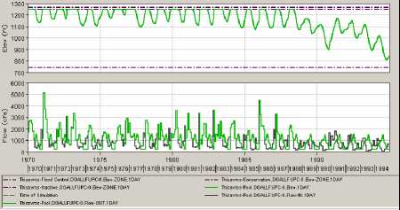
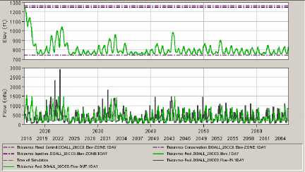
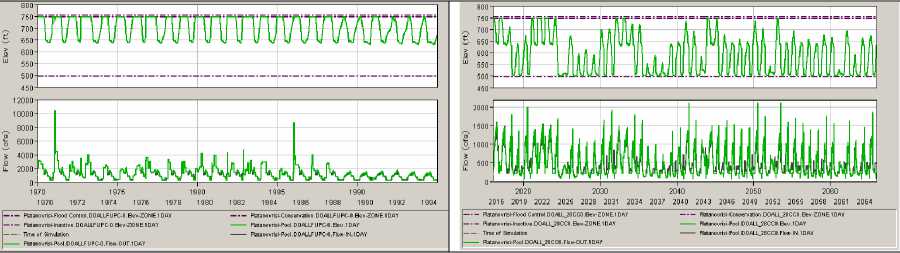
First, it is important to establish the influence of the parameters on the project alternatives. The two most important are the change in the flow, or full flow coming from the Mesta or only 28%, and the change in the climate, from a scenario where climate keep its actual shapes to the IPCC-A2 scenario. Tables 1 and 2 show the effects of those changes for the DOALL alternative. It is clearly visible that the dams can suffer a great variation of their capacity and of the power they generate according to the quantity of available water induced by climate or a restricted flow from Bulgaria. So the efficiency of the project depends a lot on the future conditions that will occur.
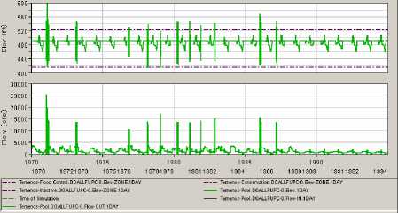
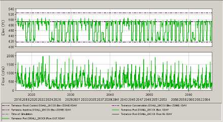
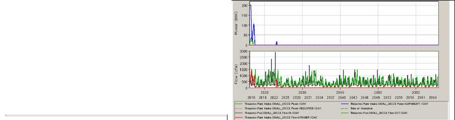
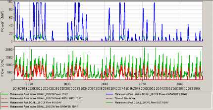
Table 3 represents the plots of elevation, flow and power production at the Temenos dam in conditions of full flow and climate change. Of course in the case of the NODO alternative only the flow plot is available. There are not many visible differences between the TDELT and the TDELX alternatives: a further more precise analysis can be done if needed. Comparing the TDELT/TDELX alternatives to the DOALL alternative, the interval of values reached is similar – due to the definition of the dam exploitation –, but the number of episodes where the level of the dam lake decreases low down its optimal level is bigger in the DOALL alternative. This means that the critical situations, where the dam will not have enough water to provide the natural delta, the irrigations, and the pumps for Platanovrisi and its own turbines, are more numerous in the DOALL alternative than in the others: this could jeopardize the viability of the project.
Another comment to understand the meaning of plots of Tables 1 to 3 is that the simulations that are represented are done with the initial hypothesis that the dams are full at the beginning of the simulation. Of course, in a real situation this is not possible: on one hand, the Temenos dam being built, it will have to be filled first, and on the other hand nothing assures that, when the Temenos dam will be launched, the other two already existing dams will be at their top level.
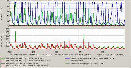
Table 1: Comparison of flow in the DOALL alternative with extreme range situations
Past Climate – Full Flow
Thisavros
Climate Change – 28% Flow
Platanovrisi
Temenos
Toxotes (releases)
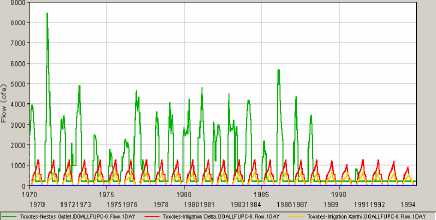
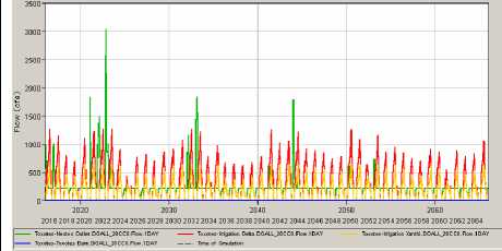
Warning: The graphics do not have the same scales.
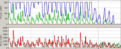
Table 2: Comparison of power production in the DOALL alternative with extreme range situations
Past Climate – Full Flow
Climate Change – 28% Flow
Thisavros
I------ Hisavos-Rsu Intake.DOALLFU PC-0. Pooler. I DAV ------ TNsavtns-Plant Intake. DOALLFUPC-0. Pouter-CAP ABILITY. ID AY
— Thisavros-Pool.DOALLFU PC-0. Flop-IN. 1 DAY ---- ThEams-Pool.DOALLFU PC-0. Flo«i-OUT.1 DAY
------ Ihlsavtos- Plant Intake. DOALLFUP C-0. Flow- □ POWER. I DAY
1970 1975 1980 1985 1998
19701971 19731974 197619771978 198019811982 19841985 198719881989 19911992 1994
Platanovrisi
Temenos
Warning: The graphics do not have the same scales.
Table 3: Comparison of flow and power plots at the level of Temenos dam in the 4 alternatives proposed –climate change, full flow–
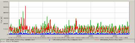
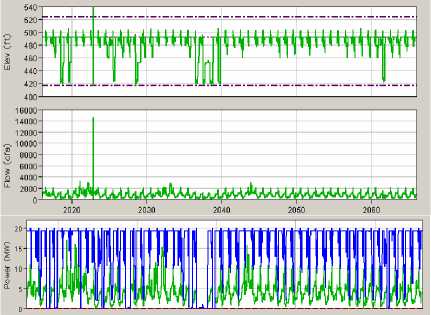
NODO
TEDLT
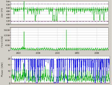
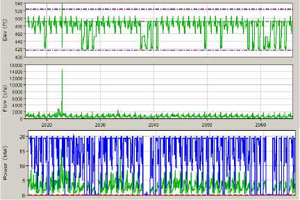
TEDLX
DO ALL
To study the economic feasibility of TEDLT, TEDLX and DOALL, the data, corresponding to each project alternative associated to the four scenarios resulting from the ResSim simulations, is transferred to Excel files. To sum up, this represents twelve Excel files: the possible combination between the 3 alternatives, Climate Change or Past Climate scenarios, and 28% of the Mesta river stream or 100% of the stream reaching the Nestos.
Each Excel file calculates, over the 50 years of lifetime project, the variation of cash flow of the economical system according to the given inputs. Consequently 3 different Net Present Values are given:
- Electricity NPV: the Net Present Value corresponding to the cash flow generated only by the selling of electricity against the investment and operational costs.
- Agriculture NPV: the Net Present Value of the cash flow generated only by the selling of irrigation water.
- Total NPV: which a sum of the 2 previous values.
In order to get realistic results, an Excel macro enables to take into account the costs or the benefits of the following topics:
- the loss of crops due to long period without water supply: a compensation will be given to the farmers,
- the economical penalty that the company will have to pay if the minimum flow for the delta isn’t provided,
- the benefits of selling back water for the Platonovrisi dam.
Figure V.1 shows the general look of the Excel files used for the economical feasibility.
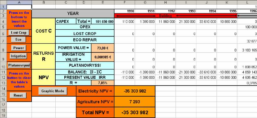
Figure V.1: example of Excel file employed
Previous studies on the Temenos Project were used to collect the investments required and the operational costs. A renewal of the turbines is planned after 20 years of service.
Some key factors, such as the selling price of the MWh, the selling price of the cubical meter of water for irrigation and the Internal Rate of Return (IRR), have to be chosen for the running of the Excel files calculation.
The current values, found for these three factors in a Michaniki Group study, are:
- price of electricity: 73 €/MWh
- price of irrigation water : 0.000 985 €/m3
- IRR: 7.85 %.
Because a scenario where the climate does not change, matches with the world’s current situation, it is considered that these values line up for the Past Climate scenarios.
For the Climate Change scenarios, the most probable evolution will be an increase of the energy demand, which will cause a tension on the energy market. So to follow this possible aftermath of the climate change, it is supposed that the price of electricity would rise. The value, chosen in these economical simulations, is fixed to 91 €/ MWh, which is in the range of the actual peak values that can be reached (source: peak value of the PowerNext market for October 2006, in Tendances Carbone, issue 8, October 2006, publishing Caisse des Dépots). No relevant information concerning the evolution of the IRR or the price of the irrigation water m3 was found, so the same values are used.
In the case the dams system could not provide the minimal flow to feed the natural delta of the Nestos, previous negotiations have established that the company will have to pay a fine as compensation for the negative impacts of the lack of water.
However it is arduous to give a price to environmental entities. Several ways can be used to try to establish the value of a given ecosystem. As it is not the theme of this study, no further explanation will be developed: the existence value of the Nestos delta natural ecosystem is set to 12 millions €/year.
V. C. RESULTS
The table V.1 shows the results of the different Excel simulations. For each alternative, the results provide 4 x 3 = 12 Net Present Values, that is to say 4 electricity NPVs, 4 irrigation NPVs and 4 total NPVs, depending on the scenario considered. The NODO alternative predictable results are also visible in the table to allow a clear comparison of the 4 alternatives considered.
Multi Criteria Decision Analysis, which is the next step of this study, will need a representative value of the NPV to evaluate the alternatives. So a choice has to be made in order to set this value, as a selection (the biggest, the lowest, the CC-28 value, the CC-full value, etc.) or as a combination of these values (average, average of the electricity NPVs, average of the irrigation NPVs, etc.). The reasons of each choice will be given in each assessment (ref part VI. B.).
Table V.1: Results of the economical simulations
|
Electricity | |||||
|
PC FU |
PC 28 |
CC FU |
CC 28 |
Representative Value | |
|
NODO |
0 |
0 |
0 |
8 |
8 |
|
TED LT |
-7 8 231 84 6 |
-21 35 3 65 7 |
-27 7 88 27 4 |
-47 161 374 |
-43 633 788 |
|
TEDLX |
-5 024 480 |
-21 39 8 89 2 |
-25 4 48 23 3 |
-62 958 185 |
-28 785 448 |
|
DO ALL |
-18 528 950 |
-38 30 9 68 6 |
-47 6 67 64 8 |
-79 287 642 |
-45 926 482 |
|
Irrigation | |||||
|
PC FU |
PC 28 |
CC FU |
CC 28 |
Representative Value | |
|
NODO |
0 |
0 |
0 |
8 |
8 |
|
TED LT |
0 |
34 788 |
7 293 |
271 794 |
78 469 |
|
TEDLX |
31 969 556 |
32 988 170 |
31 8 75 86 6 |
30 349 411 |
31 795 551 |
|
DO ALL |
64 535 563 |
66 055 644 |
61 648 655 |
50 027 753 |
68 566 984 |
|
Total | |||||
|
PC FU |
PC 28 |
CC FU |
CC 28 |
Representative Value | |
|
NODO |
0 |
0 |
0 |
0 |
0 |
|
TED LT |
-7 8 231 84 6 |
-21 35 3 65 7 |
-27 7 88 27 4 |
-47 161 374 |
-78 231 846 |
|
TEDLX |
26 945 076 |
10 28 6 92 3 |
6 2 59 6 04 |
-34 111 398 |
-34 111 398 |
|
DO ALL |
45 386 056 |
2 3 881 78 9 |
12 5 68 30 6 |
-32 895 137 |
-32 8 95 137 |
No further comment will be made on the economical results, for the final purpose of this study is to provide an assessment in order to help in a decision making between several actors, and not to judge in details the project economical viability.
The Multi Criteria Decision Analysis is based on the use of evaluation matrices where the criteria enabling the decisions face the different projects. A column matches with a criterion and a line with a project. A criterion can be of two kinds: a quantitative one and a qualitative one. When the criterion is quantitative, the column must be filled with numerical values taken from simulations or evaluations.
The only quantitative criterion used in the following MCDA is the NPV, which was filled, depending on the point of view considered, by specific values (average, the most pessimistic, the most optimistic, electricity income NPV, irrigation income NPV, and so on). Concerning qualitative criteria, which were the major type of criteria in this MCDA, each column was to be filled with an integer taken between 1 and the number of projects under study (here, it is 4), 1 granting the project that satisfies the criterion the less and 4 the project that fits the criterion demands the most.
Each criterion is then given an influence weight, whose goal is to balance the importance and significance of the miscellaneous criteria with each other, according to the actor’s point of view.
Once the alternatives have been evaluated by criterion, and the different weights established. It is possible to calculate a classification of the alternatives from best to worst.
The ELECTRE software has been designed by Lamsade (a French research group) to calculate a multi-criteria ranking of given alternatives, according to criteria and influence weights, in order to help decision makers. An essential feature of ELECTRE is the display of a chart that shows the classifying from best solutions (the ones most relevant to the problem) to worst ones.
This method is used to simulate 5 matrices representing the point of view of DEH, of the investors, of the government of Greece, of the government of Bulgaria and of the farmers. Finally these 5 different results are put into a final matrix where the alternatives are evaluated according to their ranking for the different actors of the negotiations (used as criteria) and where the influence weights are dealt according to the Bulgarian government’s point of view that asked for this assessment.
VI. B. GENERAL ASSESSMENTS
First of all, we agreed to think that, generally speaking, the lesser water streams are diverted for irrigation, the better it is for natural delta ecosystem. With the little downside implied by less irrigation water coming from the dams, which is the increase in groundwater being used. So the environmental concerns are necessarily contrary to the agrimarket issues or to the agricultural needs that are in favor of irrigation plans.
We also think that the construction of the new dam of Temenos can be advocated only if it can produce electricity, and therefore we gave more credibility to the TEDLT and TEDLX projects, since the Temenos Dam will not generate any power if the flow is low and the Drama plain is to be irrigated. Yet, the DOALL project is better for energy production than the NODO project in any way.
Another constant in these evaluation matrices is the way to weight the influence of diplomacy between Greece and Bulgaria on the choice of the Temenos Dam project. Indeed, we assumed that, in order to keep as good relations between Bulgaria and Greece, the Temenos project will only have a meaning if enough water is available on both side of the border to fulfill the two countries plans.
The principal hypothesis is that Demotiki Epiheirisi Ilektrismou (standing in Greek for ‘Public Power Corporation’s’, DEH) is in favor of the construction of the dam, for hydroelectric power is an easy way of answering peak demands.
As climate change is bound to happen, whether it will be intense or not, needs for electricity will increase with growing population and with more extreme weather conditions (warmer probably), so for DEH, building a dam that will be a source of energy, is a good option.
The downside of new infrastructures is, however, that they request construction investments and that they increase operational costs.
A relevant income for DEH is the cash-flow that can be generated by the production of electricity: the NPV is then given as an average value between the numerical calculations done for extreme climate change scenarios and for optimistic hypotheses of an unchanging climate.
Finally, DEH will certainly give greater significance to electrical incomes, to irrigation demands (and incomes) and to the future evolution of energy market than to environmental concerns.
|
Criteria Vs Alternatives |
NPV Electricity |
ENV Environment |
OPER Operating costs |
PRICE Energy market |
IRRIG Irrigation demands |
CLIM Climate change |
|
NODO |
0 |
4 |
4 |
1 |
1 |
1 |
|
TEDLT |
-44 |
3 |
3 |
4 |
2 |
4 |
|
TEDLX |
-29 |
2 |
2 |
4 |
3 |
3 |
|
DOALL |
-46 |
1 |
1 |
2 |
4 |
2 |
|
Influence Weights |
0,25 |
0,05 |
0,15 |
0,2 |
0,3 |
0,1 |
Matrix VI.1: DEH MCDA evaluation matrix
Investors are primarily focused on the profitability of the project, and because Greek and probably Bulgarian governments will support the project, the risk associated to it will be controlled (with a higher rate of return asked if risks are higher): in any case we considered that investors will point out the most pessimistic scenarios. This is represented by a worse value of the total NPV that can be reached by each project (usually for the CC-28 simulation). Associated with the rates of global economy, from return’s or exchange’s ones, we supposed that the investors will prefer to invest a
greater amount of money, and so they will prefer a solution where more things are done (like in the DOALL alternative).
We thought that it was better for the investors to support the project alternative that bring the larger development to the area, in this case by irrigating as many fields as possible. Furthermore, this will satisfy the population’s and politicians’ yearning for local development.
The way investors will approach the climate change issue in this project is the following: if the climate gets warmer and the dam cannot be run, then it will be better not to invest for the project will not be profitable.
From an investor’s point of view, it is natural to give more weight to the profitability indicators than to the environmental issues.
|
Criteria Vs Alternatives |
NPV Net Present Value |
POLIT Regional politics |
ENERGY Energy demand |
FARM Agrimarket |
CLIM Climate change |
RATES Global economy |
|
NODO |
0 |
1 |
1 |
1 |
4 |
1 |
|
TEDLT |
-78 |
2 |
4 |
2 |
3 |
2 |
|
TEDLX |
-34 |
3 |
4 |
3 |
2 |
3 |
|
DOALL |
-33 |
4 |
2 |
4 |
1 |
4 |
|
Influence Weights |
0,3 |
0,15 |
0,15 |
0,15 |
0,05 |
0,2 |
Matrix VI.2: Investors MCDA evaluation matrix
The government of Greece will not have different opinions from the other actors about environment, local and regional policies, the energy policy and the agrimarket, because the government has to take into account the different interests at stakes and find the common ground.
But the Greek government has also other responsibilities to fulfill, such as its relations with Bulgaria or the way to balance the international appraisal with its national policy, whose demands may face the disapproval of the international community.
An opposition appears intrinsically between the demands of Greek national policies, which can be sum up, in this project, by the increasing needs of Athens for electricity, and the reactions of the international community, which can be represented by the NGOs’ concerns for the environment. This opposition is a very complex matter. Indeed, if it is easy to assert that the worse project for both the environment and the production of electricity is the DOALL project because of its huge water diversions for irrigation. The best one is the TEDLT project because it answers the Athenian needs for electrical power supply without endangering the environment too much, the NODO project is not the worst one, because even if the electrical demands are not answered – at the expense of the Athenians – at least the environment is preserved – to the NGOs’ satisfaction.
To the contrary of the investors’ and the DEH’s MCDA matrices, there is no obvious criterion that should be disregarded or supported, so that the different weights are average. Still, we assumed that environmental concerns can be given more weight, because Greece’s economy depends mainly on tourism, and any damage done to the environment could have dire consequences on Greece’s flourishing tourism industry.
|
Criteria Vs Alternatives |
ENV Environment |
ENERGY Energy policy |
AGRI Agriculture economy |
BG Relations with Bulgaria |
POLICY Local & regional policies |
PUBLIC National & international policies |
|
NODO |
4 |
1 |
1 |
4 |
1 |
2 |
|
TEDLT |
3 |
4 |
2 |
3 |
2 |
4 |
|
TEDLX |
2 |
4 |
3 |
2 |
3 |
3 |
|
DOALL |
1 |
2 |
4 |
1 |
4 |
1 |
|
Influence Weights |
0,25 |
0,2 |
0,15 |
0,1 |
0,2 |
0,1 |
Matrix VI.3 : Government of Greece MCDA evaluation matrix
Regarding Bulgaria’s national water policy, it seems obvious that every attempt by Greece to use more water from the Nestos, will have consequences in the quantity and quality of water that the Greek authorities will ask to Bulgaria. So Bulgaria would prefer to have less pressure on its water resources management, and that means that Bulgaria would be in favor of the dam project that will request as little water as possible (mainly for irrigation), let alone no dam at all.
This reasoning on Bulgarian water resources can be easily employed for the Bulgarian money resources, and especially the European subsidies for Bulgaria. Indeed, the construction of a dam necessarily infers that Greece will receive more subsidies, whose amount increases depending on the complexity of the contemplated irrigation schemes, and as the global amount of subsidies remain constant: Bulgaria can expect less money. So Bulgaria would find less interesting to back a dam project with low investments, let alone no dam at all.
However, in the light of local development, Bulgaria would find it more useful to be in favor of a project that will lead to more production of electricity; expecting that, with the interconnections between electrical networks, this electricity can possibly reach the Bulgarian market. The construction of the Temenos dam with the simplest irrigation scheme would enable the dam to reach its maximum electricity productiveness level.
In comparison with the other energy policy assessments, we granted the TEDLT and TEDLX with a ‘3’ instead of a ‘4’ in order to show that Bulgaria would somehow prefer to produce its own electricity, instead of purchasing it to other countries. In the same line, not to build a dam would not be a good alternative for it would prevent any attempt of local or regional development.
Considering the membership of Bulgaria in the E.U. starting in 2007 and the previous constraints that were to be fulfilled, we assumed that Bulgaria’s relations with the E.U. are of paramount importance. For example, the majority of the necessary credit for its development comes from Europe. To express this information, we granted this criterion with the exceptional weight of 0.35. Then Bulgarian energy and local policies are the next priorities, while its relations with Greece already considered within the relations with Europe are given a lesser weight.
|
Criteria Vs Alternatives |
ENERGY Energy policy |
POLICY European & regional policies |
GR Relations with Greece |
LOCAL Local development |
WATER National water policy |
|
NODO |
1 |
4 |
4 |
2 |
4 |
|
TEDLT |
3 |
3 |
3 |
4 |
3 |
|
TEDLX |
3 |
2 |
2 |
2 |
2 |
|
DOALL |
2 |
1 |
1 |
1 |
1 |
|
Influence Weights |
0,20 |
0,35 |
0,1 |
0,20 |
0,15 |
Matrix VI.4 : Government of Bulgaria MCDA evaluation matrix
The starting point is to say that for farmers the project with the greater irrigation system always seemed to be the most profitable situation.
For the climate change question, which is bound to happen, it is rational to think that farmers will be able to adapt their crops to a dryer climate. It can also be considered that E.U. will subsidize farmers, if their crops are lost.
We used for the NPV criterion average value of the cash flows generated by the irrigation incomes in the four simulations, in order to establish a representative mean value.
The European Common Agricultural Policy (CAP) asks for a compromise between agricultural production and preservation of the environment. Thus, we established that the NODO, TEDLT and the DOALL projects don’t suit the CAP, for the first one does not increase productiveness, the second one is barely enough to sustain production, but at the expense of the environment, while the last one, even if it increases productiveness, severely damages the environment. The TEDLX project appears to be the best compromise between sustained agricultural productiveness and limited degradation of the environment.
Logically enough, the NGOs’ point of view is contrary to the farmers’ demands, yet we granted the NODO project with a ‘3’ instead of a ‘4’ to recall that if there is no irrigation programme, the farmers will pump the groundwater, which would undoubtedly damage the environment.
We considered that the most apposite criterion to farmers’ state-of-mind was the agrimarket and the cash flow generated by irrigation, since it would be the first time in
their history that Greek farmers would have to pay for irrigation water, whereas they would not pay much attention to the NGOs’ reactions.
|
Criteria Vs Alternatives |
NPV Irrigation |
AGRI Agrimarket |
CLIM Climate change |
EU Agro policy |
POLICY Local & regional policies |
NGO Environmental NGOs |
|
NODO |
0 |
1 |
1 |
1 |
1 |
3 |
|
TEDLT |
0,08 |
2 |
2 |
2 |
2 |
3 |
|
TEDLX |
32 |
3 |
3 |
3 |
3 |
2 |
|
DOALL |
61 |
4 |
4 |
2 |
4 |
1 |
|
Influence Weights |
0,2 |
0,3 |
0,15 |
0,15 |
0,15 |
0,05 |
Matrix VI.5: Farmers MCDA evaluation matrix
VI. D. FINAL ASSESSMENTS
We filled the final MCDA evaluation matrix with the solutions ranking obtained by ELECTRE for the first five MCDA evaluation matrices.
We rationally granted the investors with the heaviest weight because the project cannot be carry out without their approval. And because we assess the government of Bulgaria, we made Bulgaria weight in the decision at the same level as the investors. Close behind, come the Public Power Corporation (DEH, PPC) and the Greek government, who obviously weight tremendously in the final decision. The farmers and the NGOs are quite neglected, for we assumed that they would not have many representatives in the final meeting,themselves and that both parties would have difficulties in finding agreements within their own ranks.
|
Criteria Vs Alternatives |
DEH DEH (PPC) |
INVES Investors |
GR Greece |
BG Bulgaria |
FARM Farmers |
NGO Environmental NGOs |
|
NODO |
2 |
1 |
1 |
4 |
1 |
3 |
|
TEDLT |
2 |
1 |
4 |
4 |
2 |
3 |
|
TEDLX |
4 |
3 |
4 |
3 |
3 |
2 |
|
DOALL |
1 |
4 |
1 |
2 |
4 |
1 |
|
Influence Weights |
0,2 |
0,25 |
0,2 |
0,25 |
0,05 |
0,05 |
Matrix VI.6 : Final aggregated MCDA evaluation matrix
VI. E. FINAL RESULTS
Figure VI.1 shows the final chart calculated by ELECTRE.
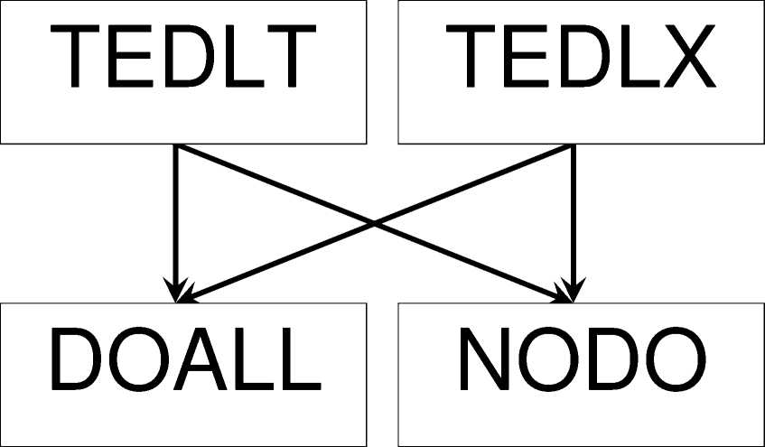
Figure VI.1 : The final chart from ELECTRE
In a matter of fact, such a result could be expected. Indeed, looking closely at the different matrices, it appears that the TEDLT or the TEDLX projects were given best ranking in each criterion.
The rejection of the extreme solutions can be accounted for by the consequences they would bring. The refusal of the Temenos dam (NODO) can lead to economic stagnation or slowdown because of the forthcoming lack of electrical power supply for industry or of irrigation for agriculture, and in the worse case causing also a degradation of the environment by urging farmers to use underground water. In the other hand, a complete irrigation programme (DOALL) could severely damage the environment of this region of Greece, especially the riparian and coastal ecosystems, jeopardizing the local tourism industry. The agriculture would benefit from such an irrigation scheme, but at the expense of the production of electricity, so that the final profitability of such a project is close to zero.
The middle solutions offer a good compromise between electricity production, irrigation demands and environmental issues. For instance, the TEDLT project seemed to be the best one to assure a sufficient production of electricity, which could answer the future needs of industry for power, with a limited impact on the environment and an irrigation program that could sustain agriculture to its current level during the first coming years of climate change. The TEDLX project, with a more significant impact on the environment, is the counterpart of the previous project as for agriculture and industry, since it would enable more fields to be irrigated, at the expense of a decreasing production of electricity.
This study has been able to evaluate 4 given alternatives of a project highly related to external factors. The results obtained help the advised party to grasp the principal benefits and disadvantages of each solution on a technical and an economic level. The choice of the best solution available regarding chosen criteria is then possible on a relatively objective basis.
In the case of the Temenos project, as counselors of the Bulgarian government we would recommend an intermediate solution. With our analysis serving as a starting point to argument its position, Bulgaria would be able to come to future meetings about the Temenos dam’s fate with structured information.
The Bulgarian government, not being directly related to the project (apart from the amount of water allowed to flow through the border), can play an interesting part in the negotiations, asking for consensus, or can decide to act in a limited way, rejecting any dialog further than the 28% of the annual flow guarantied for the Greek side of the Mesta-Nestos.
The assessment related to future water resources has been crucial to establish the importance that georeferenced data can have and therefore shows one of the many possible uses of Geointelligence.
However it is absolutely essential to understand that the quality of the results obtained by Geointelligence depends on the quality and the relevance of the chosen data. Any erroneous information can change the direction of a result; any irrelevant information will introduce useless complexity in the study. To guaranty the veracity of a solution, it is then important to be able to estimate the uncertainty margin of each data set, model or information used at any time.
29