|
 1 - Geoinformation gathering 1 - Geoinformation gathering 
- Building base maps
- Integrating petroleum resource related data : geology and geophysics
- Gathering geopolitical information : border lines, main cities, population, habitat …
- Infrastructure stacks : roads, bridges, existing pipelines …
- Environmental stacks : hydrology, agriculture practices, soils, protected areas, climate, health ....
Any relevant source is interesting
The more sources you have, the best cross-check you perform
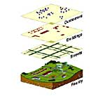
2 - Integrating layers
- That's what Geographic Information Systems are about.
- But … If you are smart, you can work efficiently without a GIS :
- Google Earth offers you possibilities to hang multiple raster documents on the remote sensing background image and open softwares like ArctoEarth allow to superimpose vector data.
- All the files in the Southern Chad Data Stack are png (allowing to manage transparency) and might be processed using PhotoShop, PaintShop Pro, …
3 - Data consistency check
Flood plains extension over hydrographic network over elevation data
Useful to verify that the 3 layers (and 3 independant sources) offer consistent informations All files are 3000 x 3216 pixels (covering 1080 x 1180 km) and provided in png
format
Square pixel size : 360 m / Square pixel area : 0,1296 km²
Files can be managed as individual layers in any image software : Photoshop, Paintshop Pro, … Coordinates : Lat/long in degree
Projection system : Nad27
4 - Simple overlay of informations
Petroleum concessions over elevation data
All files are 3000 x 3216 pixels (covering 1080 x 1180 km) and provided in png format
Square pixel size : 360 m / Square pixel area : 0,1296 km²
Files can be managed as individual layers in any image software : Photoshop, Paintshop Pro, … Coordinates : Lat/long in degree
Projection system : Nad27
5 - Logistics
Cities over roads over Pipeline over Petroleum concessions
All files are 3000 x 3216 pixels (covering 1080 x 1180 km) and provided in png format
Square pixel size : 360 m / Square pixel area : 0,1296 km²
Files can be managed as individual layers in any image software : Photoshop, Paintshop Pro, … Coordinates : Lat/long in degree
Projection system : Nad27
6 - Geointelligence at work
Refugee camps, Cities and roads over Pipeline, Petroleum concessions over flood plains and hydrography
All files are 3000 x 3216 pixels (covering 1080 x 1180 km) and provided in png format
Square pixel size : 360 m / Square pixel area : 0,1296 km²
Files can be managed as individual layers in any image software : Photoshop, Paintshop Pro, … Coordinates : Lat/long in degree
Projection system : Nad27
7 - Your own combination
- You know the question …
- You got the data …
- It's up to you !
[Top of Page]
|