Athens2006 Course
1. Brief
2. Methods
3. Principles
4. Intelligence
5. Modelling
6. Geospatial
7. Satellite
8. Economics
9. Data stack
10. Spills
11. Integration
12. Prospect
13. Development
14. Future
7. Satellite

Remote sensing from satellite - A synoptic view of the environment
T. Rousselin – ENSMP – GEO212 - France

Topics :


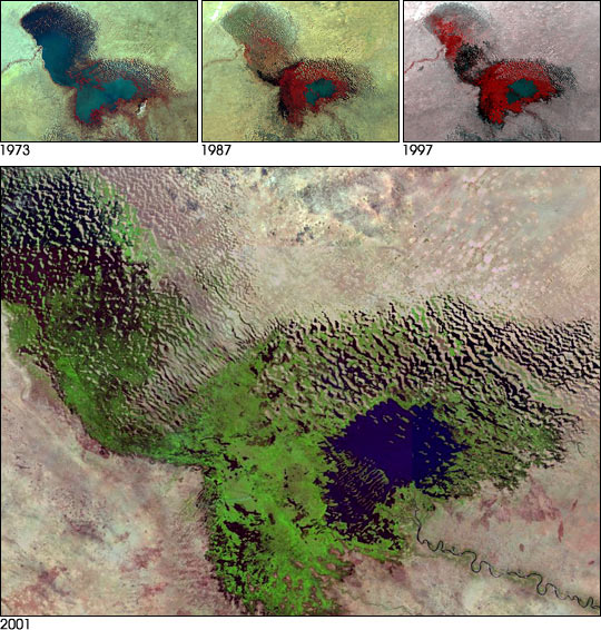
The LANDSAT 7 satellite views Chad !


 1 - Satellite remote sensing

    Observation of the Earth environment based on the measurement of interactions between the electromagnetic field and objects situated at the surface

 2 - The wavelength dimension

    • Visible : 0,35 to 0,75 microns
    • Near IR : 0,75 to 3 microns
    • Thermal IR : 3 microns to 1 mm
    • Microwaves : 1 cm to 1 meter

 3 - Physical principles

    • Reflectance (Passive) in visible and near I.R
    • Emission (Passive) in thermal I.R
    • Scattering/dielectric (Active) in visible (lidar) and microwaves (radar)

 4 - Atmospheric absorption

    Only a few observation windows allow to get field information through hundred of km of atmosphere. Large portions of the electromagnetic spectrum cannot be used due to atmospheric absorption (H20, CO2, N2O, O3, O2).

 5 - Four resolutions

    Any given observation system must balance different resolutions :

    • Spectral resolution or "how many different spectral bands will be simultaneously measured ?"
    • Radiometric resolution or "how precise your measurements will be ?"
    • Spatial resolution or "what is the smallest object you want to detect ?"
    • Temporal resolution or "do you want to measure each hour or each year ?"

 6 - A full range of sensors and systems

    Since 2002, we have a nice continuum from large field/very low resolution to narrow field/very large resolution with optical sensors and systems from Europe, USA, Canada, India, Russia, Israel, China and Japan but also Taiwan, Corea, Brasil, …

 7 - Available sensors

    By the end of 2007, with the launch of Radarsat 2 (CA), TerraSar X (GE), Cosmo-Skymed (IT) we will have the same range of systems in radar applications.

 8 - Multispectral Scanning Radiometers

    The Landsat system, through 7 satellites over 34 years, gives us a continuous coverage of the earth over 34 years. Spatial resolution has improved from 80 to 30 m. Spectral resolution has  also improved from 4 to 8 bands and from Vis/Near IR to Vis / Near IR / Thermal IR and Panchro.

 9 - Color representation

 10 - Examples of Color representations over Sarh, Southern Chad

    Color space : 3 dimensions.
    Color Mixing :

    • Additive : blue-green-red (emitted lights)
    • Subtractive : cyan-magenta-yellow (inks)
    • Satellite data presentation in color
    • False color – Ex : Thermal
    • Color composite with 3 bands

 11 - Visual interpretation of standard color composites 

    • Spectral domains : Blue, Green, Red and Infrared
    • Objects : Clean water, Muddy water, Soil and Vegetation
    • Spectral Reflectance of Common Earth Features

 12 - Radar imagery

    • Microwave sensor (wavelengths : mm to m)
    • Active sensor
    • Airborne or spaceborne (ERS, JERS, Radarsat, Envisat)
    • Difficult to interpret but complementary for optical data
    • More efficient in equatorial areas (with permanent cloud cover)

 13 - Radar pixel vs optical pixel

 14 - Radar tonal patterns

    • Geometry of radar illumination (local slope)
    • Backscattered radar return intensity

 15 - Layover, foreshortening and shadows

 16 - Surface roughness

    Surface Roughness :

    • Smooth (specular reflection or mirror)
      • Grass, savanna
      • Water: ocean, river
    • Rough (diffuse reflection)
      • Forest
    • Bright points (corner)
      • Urban : roofs, power lines …

 17 - Radar penetration

    Radar penetration varies depending on humidity. A radar signal with a 5 cm wavelength might penetrate through several meters of very dry sands in desertic areas.

 18 - Southern Chad surveillance from space

 19 - Southern Chad imagery from space

 20 - The Southwestern Chad Area (1/3)

 21 - The Southwestern Chad Area (2/3)

 22 - The Southwestern Chad Area (3/3)

[Top of Page]


Geointelligence - ATHENS Course 2006 - NTNU/ENSMP - Contact web master - Last update : 6 March 2006